Hours of walk: 4
Altitude gain: 600 m
Altitude loss: 650 m
Itinerary
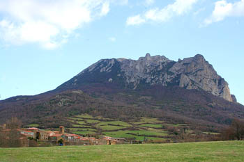
A stretch of the previous stage is to be walked again until the ruins of the Bergerie du Pla Lagal. From here the Sentier Cathare turns westbound and reaches the wood crest leading to the Roc Paradet (m 900): a garrigue-covered panoramic peak. The beautiful chalky top of the Pech de Bugarach can be seen to the north-west. The track reaches the foot of this mountain, passing near the ruins of the wide abandoned farm of Campeau (m 800). The southern side of the mountain is to be crossed along the hillside, in order to go down to the waterfalls of the Mathieux (m 545), gushing from the chalky walls of the Pech de Bugarach into a pool of crystal water. By walking along a dirt road around an artificial basin you reach the village of Bugarach, at the centre of a beautiful grass valley, with animals grazing in the enclosed fields.
Food and accommodation
-In Bugarach
Chambres d’hôtes Le Presbytère
In town, in the XVII century presbytery, tel. 33 (0)4 68 69 82 12, 4 rooms, meal service, www.presbyterebugarach.fr .
Gîte d’étape Maison de la Nature et de la Randonnée
On the south of the village, accommodates 40 guests, tel. 33 (0)4 68 69 83 88
Communauté de communes du pays de Couiza
www.paysdecouiza.fr
