Hours of walk: 7,30
Rise: 1050 m
Drop: 850 m
Itinerary
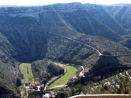
You leave Le Vigan from its southern side, walking on the Chemin de la Rivière along the Arre. After a passage beyond a bridge, you follow towards Avèze (m 247). Past the village, the GR 7 rises steeply up to the karstic upland of the Causse de Blandas. The itinerary proceeds along dirt roads used to access pastures and you should carry on making sure that the gates get closed and paying attention to the Pyrenean sheepdogs that watch over the sheep flocks. The route passes next to the village of Montardier (m 600) and the isolated castle of Arras (m 610); after reaching the edges of the village of Blandas, you follow the D 158 carriage road to then take the track that leads to the D 713, from where the extraordinary gorges of the Vis can be seen (m 612). You follow the road for a short while to come to the nice paved track leading to the gorges’ valley floor and to the village of Navacelles. From the village, you proceed on the track going along the river Vis, on its right mountain side, until the mill of La Foux (m 358). The itinerary goes on along the valley of the Vis among impressive chalky ramparts and it goes up to the village of Vissec. The last stretch is equipped with botanical notice boards describing the plants of the valley.
Food and accommodation
-In Vissec:
Aire naturelle de Vissec
For information on accommodation in Vissec you can get in touch with the town hall: la Mairie, tel. 33 (0)4 67 81 50 58.