Hours of walk: 4
Rise: 200 m
Drop: 150 m
Itinerary
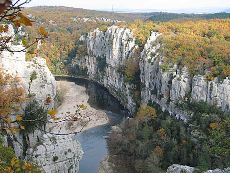
The route leaves the hamlet of Comps by its western side, to then cross almost straightaway the disused railway line and the carriage road D 111. The walk crosses a rural environment touching the hamlets of Lèbres (m 121) e Berrias (m 123). You leave the hamlet of Berrias from its northern side to cross the karstic plateau, and, at its margins, the spectacular gorges of Chassezac soon appear, the latter being an affluent of the Ardèche. After crossing the D 252, the route goes along the panoramic path of the Corniche overlooking the gorges and partly exposed, but without presenting major difficulties besides the irregularity of the rocks. This balcony path is however well-trodden. The track then leaves the cliffs to penetrate into the wood. The walk continues in a more rural environment, with dry stone walls, small fields under crop and woods, up to Les Vans.
Food and accommodation
-In Les Vans:
Hotel Le Vivarais
In the town centre, in route du Vivarais, tel. 33 (0)4 75 37 22 73. It accommodates 19 guests, with board and lodging.
Other options for food and accommodation can be found in town.
Office de Tourisme Pays des Vans
Place Léopold Ollier, Les Vans, tel. 33 (0)4 75 37 24 48.