Hours of walk: 4
Rise: 500 m
Drop: 1300 m
Itinerary
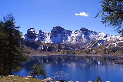
The walk leads back to the Col de la Cayolle and then up to the west heading to the Col de la Petite Cayolle (2639 m) in a particularly beautiful alpine environment: glacial lakes and peat-bogs host in late summer spectacular flowerings of crests (Eriophorum angustifolium). The path goes beyond the col, along the lake of the Petite Cayolle (2588 m), to then steeply descend on the Ravin de Méouille. There are good chances of seeing wildlife (mountain goats, chamois, marmots). You leave the GR (at an altitude of 2259 m) to follow the path on the left leading to the lake of Allos (2228 m) through a track along the mountain side. The walk goes on crossing the saddle at 2269 m, to then take the path which leads towards the north and rejoins the course of the GR. The asphalted road goes to the Plateau du Laus (2127 m), where there is an information point of the National Park of the Mercantour. You walk along the GR 56 B, crossing the state forests of the Haut Verdon (Forêt de la Cluite), up to the Allos (1414 m), a nice historical village in the valley floor of the Verdon torrent, surrounded by the recent buildings of the ski station of Super Allos.
Food and accommodation
-In Allos:
Gîte d’étape L’Autapie
Le Pradas, tel. 33 (0)4 92830631, www.lautapie.com, at about 500 m north of the historical centre